E-rate Maps of Fiber Connectivity to Schools and Libraries
Today, virtually all schools and libraries have Internet access
//fccdata.github.io/erate-map/
Skills used: HTML, CSS, jQuery, Jekyll, Mapbox.js
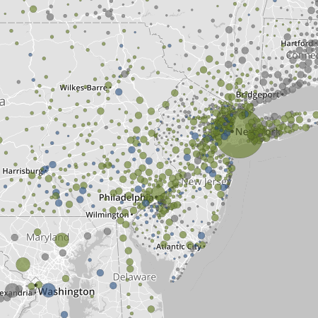
This is an interactive map that shows, by School District, the percent of public schools with fiber connectivity sized by number of students. It does not show what percent of schools within a district actually subscribe to high-speed fiber.
Again, working with the GIS team, due to other priorities I acted more as a lead/consultant.
The outcome of this project highlights the need to modernize the E-Rate program in order to provide better service to schools, libraries, and more importantly students across the United States.
A key to this map is that the FCC requested public help to gather better data on school connectivity. “The Commission has asked for comment to help identify the gap between schools’ and libraries’ current connectivity and the specific connectivity targets the Commission adopted in its E-Rate Modernization Order. Can you help by providing a district or school name that is not identified?”